
The World on Mercators Projection shewing the Voyages of Captain Cook Round the World
No Binding. 320x240mm, Overall Size: 360x280mm. Centre fold, early repairs. Hand-coloured map of the world. In very good condition. 0.
No Binding. 320x240mm, Overall Size: 360x280mm. Centre fold, early repairs. Hand-coloured map of the world. In very good condition. 0.
Edinburgh and London: William Blackwood, 1850. Half binding, half bound. This work has been selected by scholars as being culturally important and is part of the knowledge base of civilization as we know it. This work is in the public domain in the United States of America, and possibly.....
London: E. Williams, 1839. New and improved Edition. Full Calf. pp xviii, 847. Maps, tables. Full calf binding, some rubbing. Raised bands, gilt panelling and leather title label to spine. Edgewear. Marbled endpapers. Very rare.
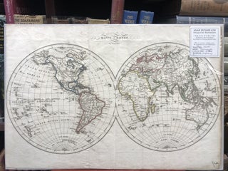
Paris: Aynes, 1813. Unbound. c. 1800s. Original coloured, engraved double-hemisphere map of the world. Free-floating & protected mylar. Full size 390mm x 260mm. A very handsome map.
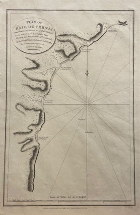
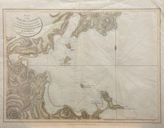
London: G.G. & J. Robinson, 1797. No Binding. Copper engraving of the Bay of Ternai, from La Perouse' voyage with the frigates La Boussole and L'Astrolabe, discovered on the 22nd June 1787. English printing, size 46.5x29.5 cm. Very clean, with locations of the frigates mapped onto the waters of the.....
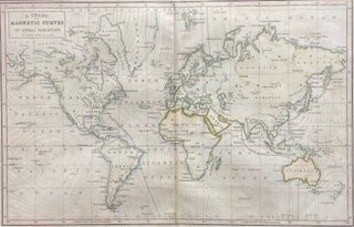
Edinburgh: Adam & Charles Black, 1854. BARLOW, Peter. Unbound. Orig coloured engraving of a map of the world showing geomagnetism/magnetic curves. Plate CCCXXVI from the General Atlas of The World. Size of image 395mm x 257mm, with mat, 490mm x 380mm. A very handsome, clean map.
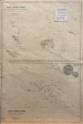
Glasgow, Edinburgh & London: Blackie & Son, 1860. No Binding. Copper engraving with colour outlines. 36.5 x 52.5 cm. Upper map: The New Hebrides, Loyalty, Feejee, and Friendly Islands &c. Lower map: The Society, Marquesas, and Low islands, &c., with Tahiti inset. Published in The Imperial Atlas of Modern Geography.....
London: Cresset Press, 1969. Original Cloth. pp 160. 12 coloured plates + many b/w illustrations. Very good in vg d/w. AD ref 364.
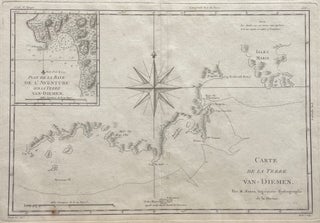
Paris: 1753. Unbound. A rare pre-Cook map showing Tasman's view of New Zealand and Australia.
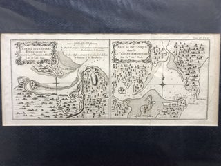
Paris: 1772. BELLIN, Jacques Nicholas. Unbound. c. 1780. Orig engraving from French Edition of Cook's Voyage showing two maps, one showing the entrance to the River Endeavour and the other of Botany Bay. Cook and his crew spent eight weeks repairing their ship (HMS Endeavour) in the estuary. Size of.....
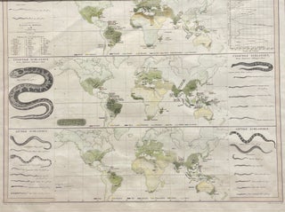
Gotha: Justus Perthes, 1845. BERGHAUS, Heinrich. Unbound. Orig German partial-coloured engraving showing three maps of the world with snake distributions. Maps are accompanied by statistical information and drawings of various snakes. Size of image 412mm x 332mm, with mat, 535mm x 330mm. A very handsome map.
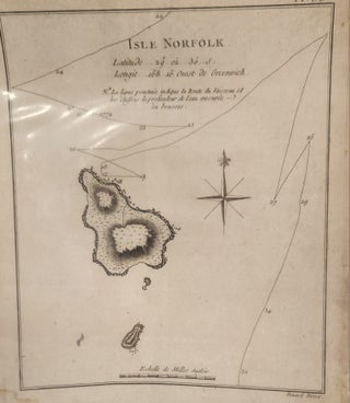
1774. Bernard. Unbound. Latitude 29..02..30 S. Longitude 168*16. Ouest de Greenwich Nd la ligne penetuee la Route du Vaisseau et les chiffres la prefendeur de l'eau mesuree en brasses. 10 October 1774. Image Size: 205x175mm, including margins: 265x200. In very good condition.
Paris: 1779. BERNARD, Robert. Unbound. Early engraved map showing a group of islands in the Gulf of Mexico including The sandwich Islands and the Chandeleur Islands. Plate No. 63. Free-floating but protected by mylar. Full size 390mm x350mm. A very nice early map.
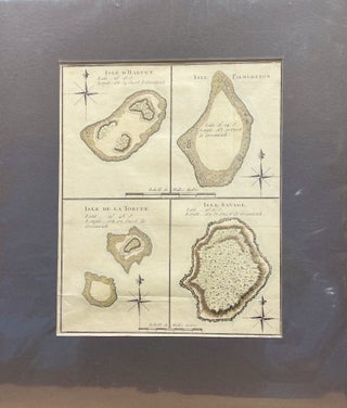
BERNARD, Robert. Unbound. c. 1790. Orig engraving showing four Cook Islands: Manuae, Palmerston Island, Vato & Niue from James Cook's Pacific Ocean Voyages. Size of image 200mm x 250mm, with mat, 320mm x 380mm. A handsome early engraving. 0.
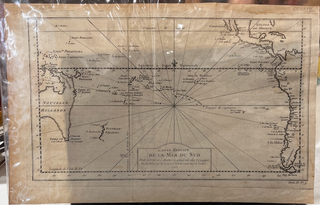
London: G.G. & J. Robinson, 1787. NEELE (engr). Unbound. Engraved by S. Neele sculpt. 352 Strand. No. 52. Original colour engraving. Size: 530mm x 415mm. Free-floating & protected by mylar. A handsome map.
Paris. Bonne. Unbound. c. 1790. Orig steel engraving of Tasmania, Cook's 3rd voyage, by M. Bonne, Naval Engineer-Hydrographer. Free-floating & protected by mylar.Size: 470mm x 315mm. Minor tears to bottom edge but else a nice map.
1780. BOWEN, Thomas. No Binding. 240x200mm, some creasing. A good, complete original engraving (c.1770-1780).
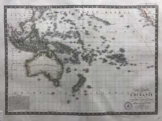
Paris: 1827. Unbound. Orig, coloured engraved French map of Oceania, depiciting Australia, New Zealand, Asia, Pacific Islands & South America. Plate No. 29 from 'Universal Atlas physical geography, politics, ancient & modern ...'. Image size 505mm x 36mm, full size, 665mm x 530mm. Freefloating & protected by mylar. A handsome.....
Paris: 1821. Unbound. Original large engraved world map with some colour. In French. Map size 360mm x 510mm, full size 535mm x 670mm. A handsome map.
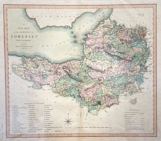
London: 1801. Unbound. An attractive hand-coloured map showing Hundreds and the reference numbers, showing the churches, dwellings, etc.
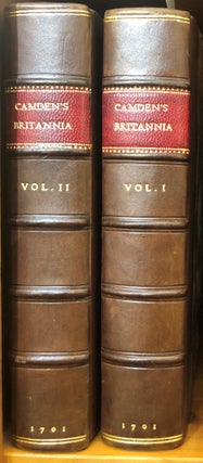
London: Joseph Wild, 1701. Orig Half Morocco. 2 vols. 53 (of 60?) folding maps. Vol 1.[24] including Life of Camden, pp 466; vol 2 [1], pp 467-842, 1-103 [Scotland], [4] index. Occasional library marks on verso of maps or odd text page. Marbled boards boards somewhat rubbed, handsomely re-spined in.....
Amsterdam: G Jansson, 1617. Hardcover. Pp. [12], 714, [26].38 maps (1 folding, which has been neatly backed/repaired), hand written list of contents on front end paper. Margins trimmed with occasional loss. Full contemporary calf, a e g, gilt decorations on spine (some wear). The rare early first Amsterdam abridged edition.....
London: J Cary, 1799. CARY, J. Unbound. Large orig coloured engraved composit map of the Russian Empire.(on 2 sheets joined at back, the numbers 37 and 38 pasted on versos.On heavy cloth. Size: 1135mm x 550mm. A very attractive map.
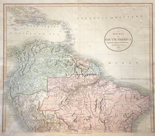
London: J Cary, 1824. CARY, John. Unbound. Orig hand-coloured engraved map showing Northern South America. Free-floating & protected by mylar. Size: 600mm x 527mm. A very handsome map.
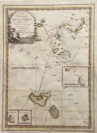
Rome: 1798. No Binding. Mount size 64x50 cm; image size 52x38 cm. Full margins, free floating with red mount. Original hand-coloured map by Cassini tracing Cook's route through the Tonga group, during his second voyage in 1773.