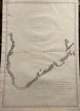
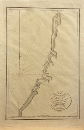
Carte Particuliere de la Baie Tasman
Paris: 1827. No Binding. Engraved map of Tasman Bay showing the coastline and the route of the Astrolabe. 60 x 100 cm, free floating behind mylar. Some foxing and slight damage at fold.
Paris: 1827. No Binding. Engraved map of Tasman Bay showing the coastline and the route of the Astrolabe. 60 x 100 cm, free floating behind mylar. Some foxing and slight damage at fold.
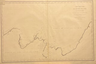
Paris: 1827. No Binding. Engraved map of the outline of the coast of the top of the South and bottom of the North Island, New Zealand, showing the route of the Astrolabe, including features of the time such as Baie du Massacre, etc. 60 x 100 cm, free floating behind.....

1895. No Binding. Tinted lithograph. Showing Ngaire, Poto and Maata districts.
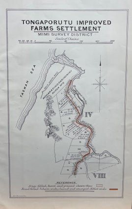
1895. No Binding. Tinted lithograph. Mimi Survey District.
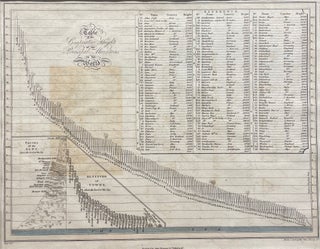
Edinburgh: John Thomson & Co. No Binding. Engraved B&W chart showing the relative heights of 156 mountains across all European countries. Insets show maps of the passes of the Alps giving heights above sea level, and altitudes of towns. 30.5 x 24, 41 x 35.5. Engravings by Nathaniel Hewitt (1783-1826).....
Auckland: 1862. Unbound. Image size 235x160mm, including margin 265x195. John Dower, FRGS from Illustrated London News, November 8 1863. Shows forts, battery & placement of ships. A hand coloured map kept in excellent condition.
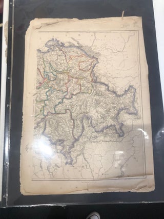
London: c. 1860. No binding. A coloured map of Switzerland.
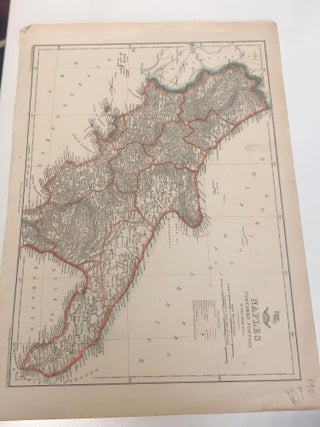
London: 1863. No binding. A map of Naples, Italy, with colours.
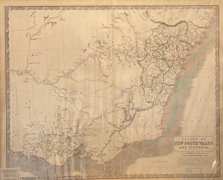
1848. No Binding. Hand-coloured dividing lines. Handsom early map.
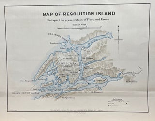
1895. No Binding. Coloured lithograph.
London: G.G. & J. Robinson. 1799. NEELE (engr). Unbound. Early, orig engraved map showing the anchorage of the L'Astrolabe and La Boussole at the Bay on the west shore of Sakalin Island, Russia. Free floating & protected by mylar. Full size: 295mm x 465mm. A very nice map.
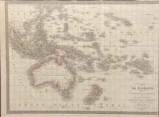
Paris: 1829. LALLEMAND, Ferdinand. Unbound. Original hand-coloured engraved map showing Oceania, including New Zealand, Australia ( Nouvelle Hollande) & Asia. Size of image 535mm x 410mm, with mat, 680mm x 545mm.68mm. A handsome map.
Paris: Chez Eymery Fruger, 1829. Unbound. Engraved map with coloured outlines. Size of map 393mm x 543mm, size of full sheet 485mm x 612mm. A rare example of an early hand-coloured French map.
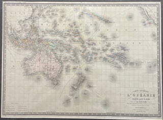
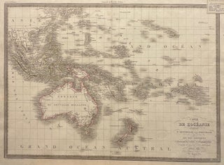
Paris. Unbound. Handsome hand-coloured engraved map showing the Pacific Islands, Australis and New Zealand.
No Binding. c. 1830. Loose on backing board. Map of Pacific Islands, Australia and New Zealand.
Paris: Lemercier, 1856. No Binding. Single sheet. Image size:42.5x29; with margins 52x35.5 cm. Fine, hand-coloured engraved regional map. No. 22, Region De L'Ouest. Imprint of Lemercier Paris. Map showing roads, raliway lines, towns and cities; statistics on communes, population, mining and minerals; information on notable personalities, agriculture, wine, and other.....
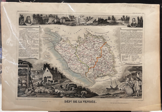
Paris: Lemercier, 1856. No Binding. Single sheet. Image size:42.5x29; with margins 52x35.5 cm. Fine, hand-coloured engraved regional map. No. 82, Region De L'Ouest. Illustrations by Couche, statistics & geography by V. Levasseur, engraving by C. Smith. Imprint of Lemercier Paris. Map showing roads, raliway lines, towns and cities; statistics on.....
Paris: Lemercier, 1856. No Binding. Single sheet. Image size:42.5x29; with margins 52x35.5 cm. Fine, hand-coloured engraved regional map. No. 48, Region De L'Ouest. Illustrations by Couche, statistics & geography by V. Levasseur, engraving by C. Smith. Imprint of Lemercier Paris. Map showing roads, raliway lines, towns and cities; statistics on.....
Paris: Dupuich, 1856. No Binding. Single sheet. Image size:40.5x28; with margins 52x35.5 cm. Fine, hand-coloured engraved regional map. No. 7, Region Du Nord. Illustrations by Perrot, geography by A. Vuillemin, engraving by Smith & George. Imprint of Dupuich a Montreuil Paris. Map showing roads, raliway lines, towns and cities; statistics.....
Paris: Lemercier, 1856. No Binding. Single sheet. Image size:42.5x29; with margins 52x35.5 cm. Fine, hand-coloured engraved regional map. No. 67, Regiondu Nord-Est. Illustrations by Beaurain, statistics & geography by V. Levasseur, engraving by Laguillerme et Rainaud. Imprint of Lemercier Paris. Map showing roads, railway lines, towns and cities; statistics on.....
Paris: Lemercier, 1856. No Binding. Single sheet. Image size:42.5x29; with margins 52x35.5 cm. Fine, hand-coloured engraved regional map. No. 25, Region Du Sud-Ouest. Illustrations by Couche, statistics & geography by V. Levasseur, engraving by C. Smith. Imprint of Lemercier, Paris. Map showing roads, railway lines, towns and cities; statistics on.....
London: Bell, 1965. Original Cloth. pp 256. 59 plates and illus. Very good in vg d/w.
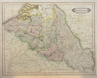
Edinburgh: John Hamilton, 1830. Unbound. c. 1830. Orig hand-coloured engraved map of the Netherlands (Belgic provinces incl. Luxembourg) with a key to the provinces. (with early names; Dutch Brabant. Size: 512mm x 415mm. Free-floating & protected by mylar.. A very handsome map. 0.
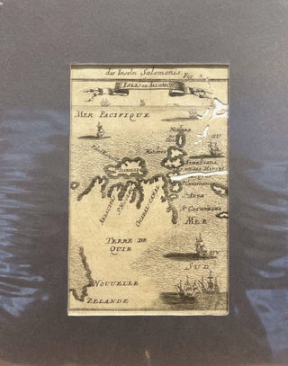
No Binding. 10 x 15.5; 21 x 27 cm. Miniature map of Solomon Islands showing recent Portuguese and Dutch discoveries, and New Zealand erroneously in the vicinity. Originally engraved and published by Mallet in 1683 in the multi-volume Description de L'Univers, this is from a later German translation. Some worm.....
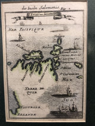
No Binding. 10 x 15.5; 21 x 27 cm.Hand-coloured miniature map of Solomon Islands showing recent Portuguese and Dutch discoveries, and New Zealand erroneously in the vicinity. Originally engraved and published by Mallet in 1683 in the multi-volume Description de L'Univers. A later German edition.