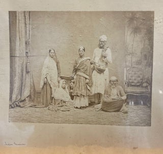
Indian Musicians (Hand-written on margin)
No Binding. c 1870. Original photograph of 5 musicians some with instruments.
No Binding. c 1870. Original photograph of 5 musicians some with instruments.
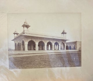
No Binding. Original photograph c 1890 of an Indian Temple. 29 x 21.5 cm on mount 48 x 34 cm.
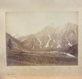
No Binding. Original photograph c 1890 of mountains in the Scind Valley. 29 x 21.5 cm on mount 48 x 34 cm.
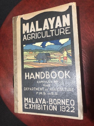
1922. Hardcover. pp 248, illustrated. Frontispiece tipped in. Original pictorial boards.
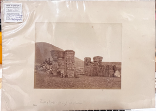
No Binding. c 1870. Original photograph of ruins in Kashmir.
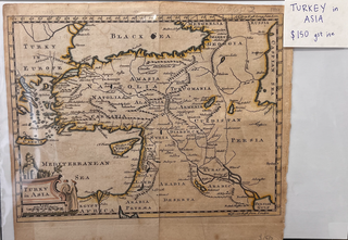
1777. Unbound. c 1777. An early hand-coloured engraved map, showing Cyprus, Candia, Syria,Arabic, Eyraca, Curdistan, Armenia, Aladulia, Carmania, Turkomania, Natolia, border with Turky in Europe, Constantinople, Amasia, Georgia and Black Sea and Mediterranean Sea. An illustrated name plate shows a building and two Turks. Tear at bottom of fold and.....
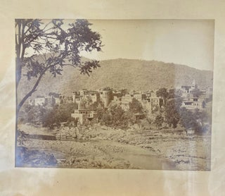
No Binding. Original photograph c 1890 of a town and riverin the Punjab. 29 x 21.5 cm on mount 48 x 34 cm.
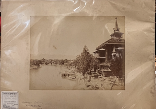
No Binding. Original photograph c 1890 of buildings and boats on the Jhetam River in the vale of Kashmir (Cashmere). 29 x 21.5 cm on mount 48 x 34 cm.
Edinburgh: McIntyre. Unbound. c. 1780s. Original coloured, engraved, hemisphere map of the world depicting three views of Africa, Asia, New Hollande (Australia) & America. Free-floating but protected by mount & mylar.Size of image 310mm x 189mm, with mat, 460mm x 355mm. A very handsome map.

Boston: Henry Hoyt, 1871. Hardcover. pp. 152. Frontispiece, original cloth, aeg. A fine copy in the original cloth.
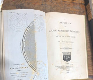
London: The Author, 1839. Cloth. pp.vii,643-650+22 blanks. Early green cloth, folding frontispiece of the Solar System. Australasian content.
London: Sampson Low, 1884. 1st Edition. Half Calf. pp xvi, 438. complete with 2 coloured plates, all engravings, illustrations and folded map. Half calf with decorative gilt spine. Some wear to extremities. Neat gilt stamp on front board. Marbled endpapers and page edges. Foxing to title page, otherwise good...

Rutland, Vermont & Tokyo: Charles E. Tuttle & Company, 1996. 1st Edition. Hardcover. 215 pp, photographic plates. Riddell was a late 19th C missionary who worked extensively with lepers, eventually working independently of the other missionaries.
London: John Murray, 1864. Half Calf. 2 Volumes. Vol I, pp vii, 556, frontis (portrait) ; pp v, 578, frontis (portrait). Half calf and marbled boards. Some rubbing to leather. Small gilt crest to lower spines, no other markings. Marbled page edges and endpapers. Some foxing to prelim pages only.....
London: Greening & Co., 1900. Cloth. pp 294, map and illustrations, red cloth binding with gilt, in good condition, a very nice copy.
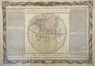
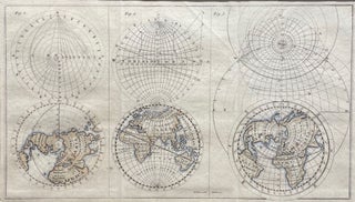
Paris. Unbound. c. 1790. Orig, hand-coloured engraved French map of the Eastern Hemisphere, showing Asia, Africa , Europe & Australia. Plate No. 9. Surrounded by ornate b&w boarder of scrolls & flowers and two panels of text Image size, 555mm x 385mm, full size 650mm x 490mm. Freefloating & protected.....
London: Allen & Co., 1880. Pictorial Cloth. pp xiii, 202, black, white & blue plates. pictorial cloth with gilt , good condition.
Calcutta, London: Thacker, Sprink & Co, 1883. MACRE, F C. Half Morocco. pp. 216. b&w illustrations throughout incl. frontis & title page. Contemp burgandy half morrocco and green cloth boards. Neat gilt stamp on spine and frontboard. Aiken was an officer in the Indian Army during the Afgan War, and.....

London: Sampson Low, 1881. Original Cloth. 2 vols. Two coloured frontispieces. Contemporary half morocco. Neat gilt stamps to front board and spine. A handsome copy of this rare work covering the entire campaign in Turkey and the Crimea. Battles of Alma, Balaclava, Inkerman and Sebastepole. An account of the Indian.....
London: Bodley Head, 1905. First Edition. Original Cloth. pp. xii, 404, Illustrations, photos. Original green cloth, gilt spine titles and gilt image, lion's head, to front boards. Hinges weakening and tape repaired on the inside but binding still firm. Edgewear and some rubbing to boards. Signatures to ffep.
London: Sampson Lowe, Marston & Co, 1933. 1st Edition. Hardcover. xv, 336 pp, frontispiece, 7 plates, original cloth, dust jacket. An account of pirating and notable pirates in the Indian and Asian seas by Charles Grey, a retired soldier living in Lahore. Scarce with dust jacket.
Edinburgh: Douglas, 1898. Original Cloth. Pp. xii, 412. Frontispiece, vignette & 9 plates & 1 double-page map. . Neat gilt stamps to front board and spine. Naval Action. Sebastopol. China. India etc) A good copy in original cloth.
London: Archibald Constable & Co, 1905. Cloth, Orig. Frontis photographs + plates and folding map. Contemporary Cloth. Gilt stamp on frontboard. Stain on front board and light foxing to frontpages but else a good copy. Account of the petroleum industry in the Caucasus, written by the editor of Petroleum World.....

Auckland: 1862. Unbound. Image size 235x160mm, including margin 265x195. John Dower, FRGS from Illustrated London News, November 8 1863. Shows forts, battery & placement of ships. A hand coloured map kept in excellent condition.
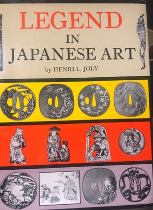
Tokyo: Charles E Tuttle Company, 1967. Reprint. Hardcover. pp 623 Frontis (colour), plates (16 in colour), illustrations. Cloth binding with gilt pictorial to front board and spine. Reprint of the classic 1908 publication describing 'historical episodes, legendary characters, folk lore, myths and religious symbolism' in Japanese art. In slip case.....